
REVOLUTIONIZING CONSTRUCTION WITH 3D LASER SCANNING
In the ever-evolving realm of construction, precision, accuracy, and efficiency are paramount. The construction industry has seen a revolutionary transformation with the advent of 3D laser scanning technology. This groundbreaking innovation has enabled professionals to capture, analyze, and utilize three-dimensional representations of construction environments with unprecedented speed and precision.
In this blog, we will delve into the fascinating world of 3D laser scanning and explore its myriad applications within the construction sector. From understanding the fundamental mechanics of laser scanning to the practical advantages it offers, we will navigate through the intricate landscape of this cutting-edge technology.
We’ll uncover how 3D laser scanning is redefining the way we approach construction projects, enhancing safety measures, reducing errors, and enabling early detection of potential issues. Moreover, we will explore the diverse range of applications, from capturing existing building conditions to monitoring structural deformations and even simulating construction processes virtually.
As we journey through this blog, we’ll also shed light on the various types of laser scanners available, such as terrestrial, mobile, and aerial scanners, and guide you in choosing the most suitable one for your specific project needs.
By the time you finish reading, you’ll have gained a comprehensive understanding of 3D laser scanning’s profound impact on the construction industry and its potential to revolutionize the way we build, design, and manage construction projects. So, let’s embark on this enlightening exploration of how 3D laser scanning is reshaping the construction landscape.
How 3D Laser Scanning Works
3D laser scanning is a technological marvel that operates on the principles of laser technology and computer science. This section will provide an insight into the mechanics of 3D laser scanning and how it captures intricate details of construction environments.
1. Laser Emission and Reflection
At the heart of 3D laser scanning is the emission of laser beams. A 3D laser scanner emits a laser beam that travels to various surfaces within its range. These surfaces can be anything from walls and objects to terrains and structures.
2. Measuring Time of Flight or Phase Shift
The scanner measures the time it takes for the emitted laser pulse to travel to the surface and bounce back. Alternatively, it can measure the phase shift of the laser pulse, which occurs as it interacts with the surface. By precisely measuring these parameters, the scanner calculates the distance between itself and the surface it hit.
3. Generating a Point Cloud
As the scanner sweeps its laser beam across the environment, it records millions of these distance measurements per second. These measurements create what is known as a “point cloud.” A point cloud is a collection of 3D data points that represent the surfaces and objects within the scanned area. Each point in the cloud contains coordinates (X, Y, Z) that define its position in 3D space.
4. Combining Data Points
By scanning multiple locations and combining the data points, the scanner builds a highly detailed and accurate 3D representation of the scanned environment. This representation is often referred to as a “point cloud model.”
5. Creating a 3D Model
To make this data more usable, it is often converted into a 3D model. Specialized software processes the point cloud, connecting adjacent points to form surfaces and objects. This results in a comprehensive 3D model that faithfully replicates the physical space.
6. Color and Texture Mapping (Optional)
Some advanced scanners also capture color and texture information in addition to distance measurements. This allows for the creation of visually realistic 3D models, adding another layer of detail to the scanned environment.
Applications in Construction
The applications of 3D laser scanning in the construction industry are wide-ranging and transformative. From documenting existing conditions to enhancing safety and efficiency on construction sites, let’s explore the diverse ways in which this technology is making a significant impact.
1. Capturing Existing Building Conditions
One of the primary uses of 3D laser scanning in construction is to capture accurate representations of existing buildings and structures. This is invaluable for renovation projects or when adding new components to an existing structure. Scanning provides precise measurements and detailed visual data that architects and engineers can use to plan modifications effectively.
2. Topographic Surveys with Laser Scanning
Traditional topographic surveys are time-consuming and can be prone to errors. Laser scanning offers a quicker and more accurate alternative. It allows surveyors to map the terrain, including elevation data, with exceptional precision. This is crucial for site preparation and foundation design.
3. Structural Deformation Detection
Construction professionals use laser scanning to monitor structural deformations and movements in real-time. This is especially critical for large and complex structures like bridges and high-rise buildings. The technology can detect even minor shifts or deformations, enabling early intervention to prevent potential disasters.
4. Enhancing Safety on Construction Sites
3D laser scanning aids in improving safety on construction sites by enabling the identification of hazardous conditions. Scanners can detect issues like cracks, unstable areas, or weak structural points. This information helps project managers implement safety measures and avoid accidents.
5. Early Problem Detection
The ability to scan and create detailed 3D models of construction sites allows for early detection of design or construction discrepancies. By comparing the scans with architectural plans, any deviations or errors can be identified and addressed before they lead to costly rework.
6. Creating Accurate 3D Models
Laser scanning is instrumental in generating highly accurate 3D models of construction projects. These models serve as valuable references for architects, engineers, and contractors. They can be used to visualize designs, identify potential issues, and streamline communication among project stakeholders.
7. As-Built Plans and Volume Calculations
3D laser scanning helps create accurate as-built plans, which document the final state of a construction project. This information is essential for future maintenance and renovation work. Additionally, the technology enables precise volume calculations for excavation and material planning.
8. Virtual Construction Simulations
Construction teams use laser-scanned data to create virtual construction simulations. These simulations allow for comprehensive planning, including the sequencing of construction activities and assessing the feasibility of different approaches. This minimizes risks and optimizes project timelines.
Utilizing Scanned Data
Once 3D laser scanning has captured detailed information about a construction environment, the data collected can be leveraged in various ways to enhance the construction process and decision-making. In this section, we will explore how scanned data is utilized effectively in construction projects.
1. Creating Accurate 3D Models
One of the most significant advantages of 3D laser scanning is its ability to create highly accurate 3D models of construction sites and structures. These models serve as the foundation for design and planning. Architects and engineers can use them to visualize the existing conditions and integrate proposed changes seamlessly.
2. As-Built Plans and Documentation
Scanned data plays a crucial role in generating as-built plans and documentation. These plans represent the actual state of a construction project once it’s completed. They are invaluable for future renovations, maintenance, or expansion, as they provide precise details about the structure and its components.
3. Volume Calculations and Material Management
Construction projects often involve excavation, backfilling, and the movement of large quantities of materials. 3D laser scanning enables accurate volume calculations of materials such as soil, gravel, or concrete. This information is essential for efficient material management and procurement.
4. Clash Detection and Interference Analysis
In complex construction projects with various systems and components, 3D laser scanning can be used to detect clashes and interferences. By overlaying design models with scanned data, construction teams can identify conflicts early in the planning phase, preventing costly rework and delays.
5. Virtual Construction Simulations
3D laser-scanned data forms the basis for virtual construction simulations. These simulations allow project teams to visualize the entire construction process digitally. This includes the sequencing of tasks, equipment placement, and safety planning. Virtual simulations help identify potential issues and optimize construction workflows.
6. Quality Control and Assurance
Scanned data can be compared against design specifications to ensure that construction work meets the desired quality standards. This is particularly important for critical structural elements and complex architectural features. Any discrepancies can be identified and rectified promptly.
7. Progress Monitoring and Reporting
Construction progress can be effectively monitored using repeated laser scans taken at different stages of the project. By comparing scans over time, project managers can assess progress, identify delays, and make data-driven decisions to keep the project on track.
8. Asset Management and Maintenance
Beyond construction, 3D laser scanning contributes to better asset management. The detailed scans can be used to create digital twins of structures, making it easier to plan maintenance activities, track deterioration, and extend the lifespan of assets.
9. Cost Estimation and Budgeting
Scanned data provides a solid foundation for cost estimation and budgeting. With accurate 3D models and as-built documentation, construction companies can create more precise cost projections and reduce the risk of budget overruns.
Monitoring Construction Progress
Construction projects are complex endeavors that require careful oversight to ensure they stay on track. 3D laser scanning is a powerful tool for monitoring construction progress, providing real-time insights and accurate data that enable project managers to make informed decisions. In this section, we’ll explore how 3D laser scanning is utilized to monitor construction progress effectively.
1. Scanning at Various Project Stages
To monitor construction progress comprehensively, laser scanning is performed at multiple stages throughout the project’s lifecycle. These stages can include:
Pre-construction: Scanning the site before construction begins to establish a baseline of existing conditions.
During construction: Regular scans are conducted as construction progresses, typically at key milestones or critical phases.
Post-construction: A final scan is done to document the completed project for as-built records.
2. Assessing Work Completed
By comparing scans taken at different stages, project managers can assess the work completed against the project schedule. This helps identify areas where construction may be lagging or progressing ahead of schedule.
3. Detection of Deviations
3D laser scanning can detect deviations from the original design plans. If the scans reveal that the construction deviates significantly from the design, it may indicate a need for adjustments or corrections. Early detection of these deviations can prevent costly rework.
4. Verification of Critical Measurements
Construction projects often involve critical measurements, such as precise positioning of structural elements or machinery. Laser scanning allows for the verification of these measurements, ensuring that everything is in alignment as per the design.
5. Quality Control
Scanned data can be used for quality control purposes. Project managers can compare the scans against quality standards and specifications to ensure that construction work meets the desired quality levels. Any discrepancies can be addressed promptly.
6. Documentation for Stakeholders
3D laser scans provide a visual record of the construction progress that is easy to understand for all stakeholders, including clients, architects, and subcontractors. These visual records are useful for reporting and communication, helping to keep everyone informed about the project’s status.
7. Volume Calculations
Laser scanning can calculate the volume of materials moved during construction, such as excavated soil or concrete poured. This data is essential for tracking progress and managing resources effectively.
8. Visualizing Complex Phases
During the construction of complex structures or intricate architectural features, laser scanning can provide detailed visualizations. This helps project teams better understand how individual components come together and how various systems interact.
9. Dispute Resolution
In case of disputes or disagreements during construction, 3D laser scans can serve as objective evidence to resolve issues related to progress, quality, or compliance with design specifications.
10. Record Keeping
Laser scanning produces a digital record of the construction process. These records are invaluable for future reference, maintenance, and renovations.
In summary, 3D laser scanning offers construction project managers a powerful tool to monitor progress, maintain quality control, and ensure that the project aligns with design specifications. By capturing accurate data at various stages, construction teams can identify and address issues early, leading to more efficient and successful construction projects.
Specialized Use Cases
3D laser scanning is a versatile technology with applications that extend beyond general construction monitoring and documentation. In this section, we’ll delve into some specialized use cases where 3D laser scanning plays a pivotal role in the construction industry.
1. Verification of MEP Installations
Mechanical, Electrical, and Plumbing (MEP) installations in large buildings can be extremely complex. 3D laser scanning is used to verify the precise placement of MEP components, ensuring they align with the design plans. This minimizes clashes and reduces the need for costly adjustments during construction.
2. Documentation of Demolition Processes
Before demolishing existing structures, 3D laser scanning is employed to document the condition of the building. This not only provides a visual record of the structure but also aids in planning and executing the demolition process safely and efficiently.
3. Deformation Monitoring
In construction projects where ground movement or structural deformation is a concern, such as tunnels or bridges, 3D laser scanning is used to monitor and detect even minor changes over time. This early warning system allows for timely intervention to prevent potential hazards.
4. Mapping of Underground Works
When dealing with subsurface construction, like tunnels, pipelines, or utility installations, laser scanning is instrumental in mapping the underground environment. This data helps in accurate planning, preventing accidental damage to existing utilities, and ensuring efficient utilization of space.
5. Heritage Preservation and Restoration
3D laser scanning plays a vital role in heritage preservation and restoration projects. It allows for the creation of highly detailed 3D models of historic structures, sculptures, and artifacts. These models aid in the restoration process, ensuring that historical sites are preserved accurately.
6. Industrial Plant Layout and Maintenance
In industrial settings, such as manufacturing plants or refineries, laser scanning is used for plant layout and maintenance. It helps in optimizing the placement of machinery, detecting wear and tear, and planning maintenance activities.
7. Scanning for Custom Fabrication
For projects involving custom fabrication or retrofitting, laser scanning is used to capture precise measurements and dimensions of existing structures or components. This data guides the fabrication process, ensuring a perfect fit.
8. Construction in Challenging Environments
In remote or challenging environments, such as offshore oil rigs or extreme weather conditions, laser scanning is employed to monitor construction progress and assess the impact of environmental factors on structures.
9. Bridge and Roadway Inspection
Laser scanning is used for inspecting bridges and roadways. It provides detailed information about the condition of these critical infrastructure elements, helping authorities plan maintenance and repairs.
10. Artistic and Architectural Projects
Architects and artists use 3D laser scanning to capture detailed information about complex architectural or artistic designs. This data serves as the basis for creating accurate reproductions or sculptures.
Types of Laser Scanners
Laser scanning technology comes in various forms, each designed to cater to specific project requirements and conditions. In this section, we’ll explore the different types of laser scanners commonly used in the construction industry.
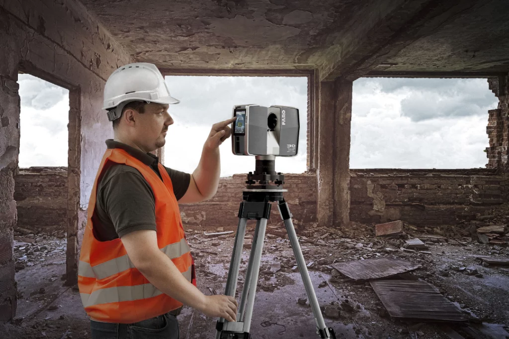
1. Terrestrial Laser Scanners
Overview: Terrestrial laser scanners are the most common type of laser scanners used in construction. They are stationary devices that emit laser beams in a 360-degree or panoramic fashion, capturing data from all directions.
Applications:
- Documenting existing building conditions.
- Creating accurate 3D models of structures.
- Monitoring construction progress at specific locations.
- Conducting detailed structural inspections.
2. Mobile Laser Scanning Systems
Overview: Mobile laser scanning systems are mounted on vehicles, such as cars, trucks, or drones. These systems use lasers and advanced positioning technology to capture data while in motion.
Applications:
- Mapping large areas quickly.
- Conducting topographic surveys of extensive sites.
- Monitoring infrastructure, such as roadways or railways.
- Collecting data in challenging or remote environments.
3. Aerial Laser Scanners
Overview: Aerial laser scanners, also known as airborne or LiDAR (Light Detection and Ranging) systems, are mounted on aircraft or drones. They emit laser pulses towards the ground and measure the time it takes for the laser to return, creating detailed 3D maps of the terrain below.
Applications:
- Mapping large areas from the air.
- Conducting topographic surveys of extensive landscapes.
- Monitoring environmental changes, such as erosion or forest growth.
- Surveying power lines, pipelines, and transportation networks.
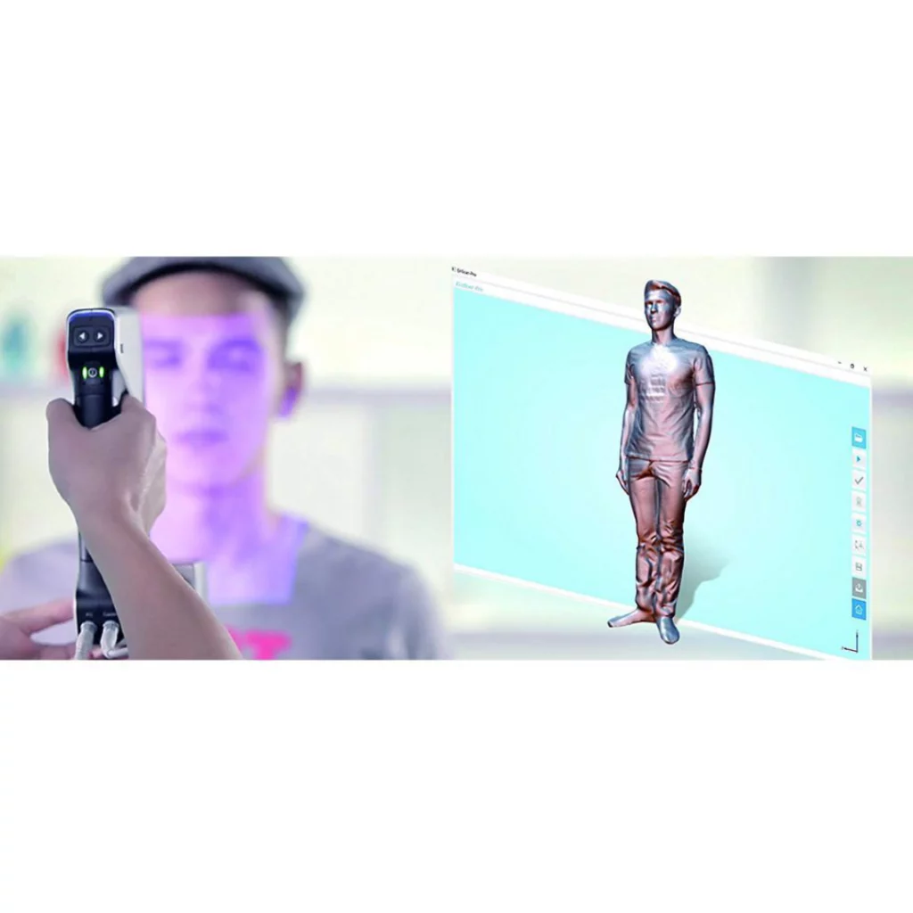
4. Handheld Laser Scanners
Overview: Handheld laser scanners are portable devices that can be operated by hand. They are typically used for capturing data in confined spaces or for smaller objects and components.
Applications:
- Scanning interior spaces, especially areas that are difficult to access.
- Capturing small, intricate details for restoration or custom fabrication.
- Creating 3D models of objects for design and prototyping.
5. Multifunctional Scanners
Overview: Multifunctional scanners combine laser scanning with other sensors, such as cameras or thermal imaging devices, to provide a more comprehensive view of the environment. These scanners are often used for specialized applications where additional data is required.
Applications:
- Combining laser scanning with thermal imaging for building envelope inspections.
- Integrating cameras for color and texture mapping in 3D models.
- Utilizing multiple sensors for detailed structural analysis.
6. Ground-Penetrating Radar (GPR)
Overview: Ground-penetrating radar is a specialized type of scanner that uses radar waves instead of lasers to penetrate the ground and detect subsurface structures, utilities, or anomalies.
Applications:
- Locating underground utilities, pipes, and cables.
- Conducting archaeological surveys to uncover buried artifacts.
- Assessing pavement conditions and detecting voids beneath roadways.
The choice of laser scanner type depends on the specific needs of the construction project, the level of accuracy required, the size of the area to be scanned, and the environmental conditions. Construction professionals often select the most suitable scanner based on these factors to ensure efficient and precise data capture.
AChoosing the Right Scanner for Your Project
Selecting the appropriate laser scanner for your construction project is a critical decision that can significantly impact project outcomes. To make an informed choice, consider the following factors:
1. Project Size and Scope:
- Large-Scale vs. Small-Scale: Determine whether your project is large-scale, like a citywide mapping project, or small-scale, such as a renovation or interior design project. Larger projects may require mobile or aerial scanners, while smaller projects may benefit from handheld or terrestrial scanners.
2. Accuracy and Precision:
- High Precision: For projects demanding high precision, such as structural analysis or archaeological surveys, choose scanners with submillimeter accuracy. Terrestrial or handheld scanners often provide the required precision.
- Moderate Precision: Projects like as-built documentation or site surveys may require moderate precision, typically achievable with terrestrial or mobile scanners.
- Lower Precision: When precision requirements are lower, such as monitoring large construction sites, aerial scanners may suffice.
3. Data Volume and Speed:
- High Data Volume: Large-scale projects generating massive data volumes, like city mapping, demand scanners with high data capture rates. Mobile or aerial scanners are suitable for rapid data collection.
- Moderate Data Volume: For projects with moderate data needs, such as building inspections or interior design, terrestrial or handheld scanners are sufficient.
- Lower Data Volume: Smaller projects, like individual room scans or small structure documentation, can benefit from handheld scanners due to their portability and ease of use.
4. Environmental Conditions:
- Indoor vs. Outdoor: Consider whether your project primarily takes place indoors or outdoors. Some scanners are better suited for particular environments. For example, mobile scanners are ideal for outdoor terrain mapping, while handheld scanners excel in indoor spaces.
5. Mobility and Accessibility:
- Accessibility Constraints: Assess the accessibility of your project site. Sites with restricted access may require handheld scanners that can easily navigate tight spaces.
- Mobility Requirements: For projects that span extensive areas, like highway construction, mobile or aerial scanners provide mobility.
6. Budget Constraints:
- Budget: Consider your project budget. High-precision scanners with advanced features tend to be more expensive. Balance your project’s requirements with budget limitations.
7. Additional Sensors:
- Sensor Integration: Determine if your project benefits from additional sensors, such as cameras or thermal imaging. Multifunctional scanners provide valuable data beyond laser scanning alone.
8. Data Processing and Software:
- Data Processing: Assess the capabilities and compatibility of data processing software. Some scanners come with proprietary software that may or may not meet your needs.
9. Support and Training:
- Training: Ensure that your team is adequately trained to operate the chosen scanner. The availability of training and support from the scanner manufacturer can be crucial.
10. Future-Proofing: – Scalability: Consider whether your project requirements may change or expand in the future. Choosing a scanner that can adapt to evolving needs can be advantageous.
Challenges and Future Trends in 3D Laser Scanning for Construction
As 3D laser scanning technology continues to evolve, it faces both challenges and exciting future trends within the construction industry. Let’s explore some of these challenges and trends:
Challenges:
1. Cost and Accessibility: High-quality laser scanners can be costly, which may limit their accessibility for smaller construction firms or projects with tight budgets. Efforts to reduce the cost of scanning equipment and services will help democratize the technology.
2. Data Processing Complexity: Managing and processing the vast amount of data generated by laser scanners can be a complex and time-consuming task. Streamlining data processing and analysis through automation and improved software is an ongoing challenge.
3. Integration with Existing Workflows: Integrating laser scanning seamlessly into existing construction workflows and software platforms can be challenging. Ensuring compatibility and interoperability with BIM (Building Information Modeling) and other tools is essential for widespread adoption.
4. Training and Expertise: Effective use of laser scanning requires specialized training and expertise. Construction professionals need to become proficient in operating the technology and interpreting the resulting data.
5. Data Security and Privacy: Laser scanning may capture sensitive information about buildings or sites. Protecting this data from unauthorized access or use is a growing concern, especially with the rise of digital twin technology.
Future Trends:
1. Increased Automation: The future of laser scanning lies in automation. Smart scanners equipped with artificial intelligence and machine learning capabilities will be able to process and analyze data in real-time, reducing the need for extensive manual intervention.
2. Integration with Augmented Reality (AR) and Virtual Reality (VR): Laser scanning data will be increasingly integrated with AR and VR technologies. This will allow construction professionals to visualize designs and project progress in immersive environments, improving collaboration and decision-making.
3. Miniaturization and Portability: Laser scanning devices are likely to become more compact and portable, making them easier to use in confined spaces or remote locations. Handheld and mobile scanners will continue to evolve.
4. Improved Accuracy and Speed: Advances in laser technology will lead to scanners that offer even higher levels of accuracy and faster data capture. This will further enhance their utility in various construction applications.
5. Environmental Sensing: Laser scanners may incorporate environmental sensors to detect conditions such as temperature, humidity, and air quality. This data can be valuable for assessing the impact of environmental factors on construction projects.
6. Sustainable Construction: Laser scanning will play a role in promoting sustainability by helping construction professionals optimize designs, reduce waste, and improve energy efficiency.
7. Cloud-Based Collaboration: The cloud will facilitate collaboration among construction teams working with laser scanning data. It will enable real-time sharing, analysis, and decision-making across project stakeholders, regardless of their physical location.
8. Regulatory Compliance: As laser scanning becomes more prevalent, regulations and standards may emerge to govern its use in construction. Adhering to these standards will be crucial for ensuring data accuracy and reliability.
In conclusion, 3D laser scanning is poised to continue reshaping the construction industry by addressing current challenges and embracing future trends. As technology advances and becomes more accessible, construction professionals can expect greater automation, enhanced accuracy, and seamless integration with other digital tools, ultimately leading to more efficient and sustainable construction practices.